
It is difficult to get to some places to travel on the Earth because of their remoteness, to others because of the harsh climate, and to others because of the turbulent political situation. We have collected ten places where you are unlikely to go after the end of the pandemic, although you may get a couple of ideas for future trips.
Turkmenistan
An absolutely amazing country with its own special little world. Here, clearly, narcissistic rulers erect golden monuments to their loved ones, write instructive books about all walks of life, shoot videos for their own songs, and deny the presence of coronavirus in the country. In general, this is a kind of North Korea, with the only difference being that getting to North Korea as a tourist is as easy as shelling pears – you just need to buy an official tour.
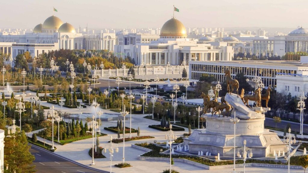
This scheme will not work with Turkmenistan. There are tour operators and tourist visas here, but they don’t issue them to almost anyone. This is not a story about specific countries, like the one about how it is difficult for a conventional Syrian to get into the conventional USA – the Turkmen have made everyone equal and refuse regardless of citizenship. The local president, with the difficult-to-pronounce name Gurbanguly Berdimuhamedov, decided to limit his subjects’ contact with the outside world and not allow foreigners into the country. By the way, it is also quite difficult for the Turkmen themselves to go abroad.
For a long time, there was a loophole in the form of a transit visa. Citizens of former USSR countries applied for it in Iran and asked for transit to visa-free Uzbekistan. The visa was usually issued for five days, during which one could have time to see the center of Ashgabat, richly lined with marble and gilded statues, and the Darvaza crater burning in the middle of the desert. But now, this opportunity has been closed, and there is no hope for improvement.
Ascension Island
A volcanic island in the South Atlantic, it is part of one of the British Overseas Territories – these are islands scattered throughout the globe that are subject to British sovereignty, but they are not part of Great Britain. For example, the laws here may be local, but sentences are passed on them by British judges, who especially periodically come here from Europe. Along with the British pound sterling, they also pay in their own currency, and the army of the United Kingdom must defend this piece of land from enemies.

The visa policy here also differs from the British one, and Turkmen’s ideas of equality have not taken root here – citizens of some countries can get here by applying for an electronic visa, while for others, entry to the island is simply prohibited by local laws. Among the latter are Belarus, Russia, and Ukraine. The blacklist is small – only 13 states and three post-Soviet republics have a decent company: Vietnam, Hong Kong, Egypt, Iran, China, Libya, Macau, North Korea, Syria, and Taiwan.
The fact is that on the island, there is a British-American military base, as well as a British-American electronic intelligence station, a GPS antenna, NASA, and European Space Agency laboratories. Until the beginning of the century, tourism did not exist here in principle, although this was more likely due to the inaccessibility of the island.
Tourists whose passports are not suspicious usually arrive on the island during Atlantic cruises. If the waves allow you to approach the island by boat, you can go ashore and see the few local attractions: birds, turtles, colonial architecture, and “the worst golf course in the world” – that’s what even the island’s official website once called the area strewn with volcanic sand.
Gaza Strip
The Palestinian state, one of the difficult places to travel, consists of two enclaves: the West Bank and the Gaza Strip. A lot of tourists go to the first one – they visit biblical places, look at Banksy’s graffiti, and try Levantine cuisine. The second is a narrow strip of land measuring approximately 40 by 10 kilometers, sandwiched between Israel, Egypt, and the Mediterranean Sea. There is not even such a thing as visiting for the purpose of tourism. Moving in here, as well as leaving, is not the most trivial task. The authors of the backpacker’s bible Lonely Planet honestly admit that they also could not get there and recommend their readers not even try, citing the difficult military situation.
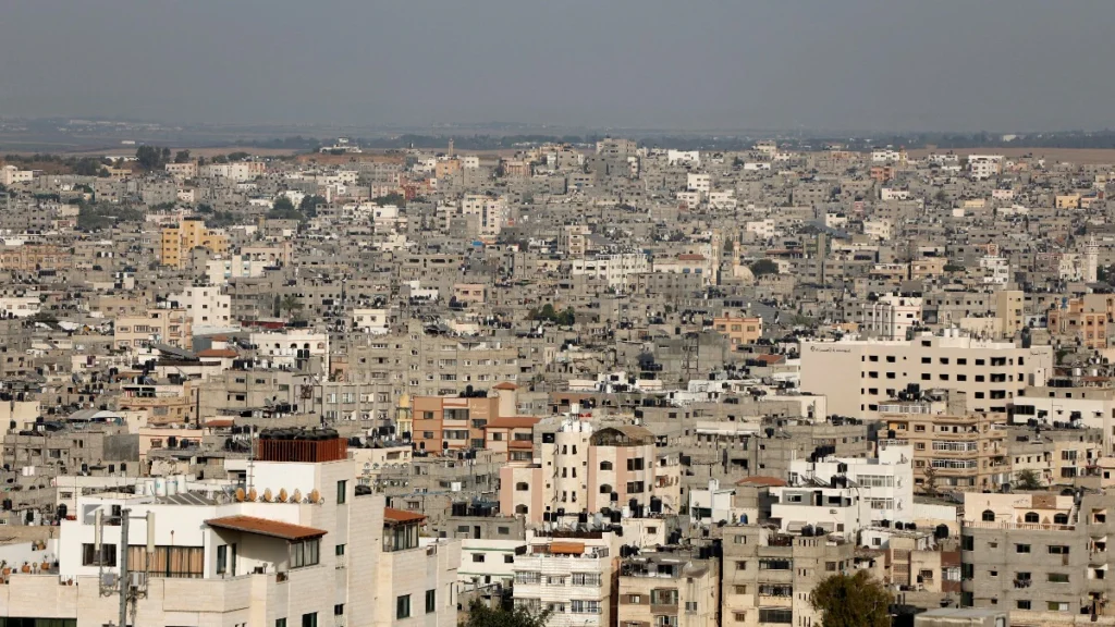
Until 2005, the situation in the Gaza Strip was approximately the same as in the West Bank: part of the region where Jewish settlements were located was controlled by Israel, and the rest by the Palestinian Authority. Local Arabs even regularly traveled to Israel to work. There were hardly any tourists in Gaza in those years, but this can be explained by the insecurity of the region. In 2005, the Israeli army and its citizens left the Gaza Strip – they even removed graves from Jewish cemeteries so that the Arabs would not desecrate them. The following year, Islamic fundamentalists won the local elections, and a year later, during the civil war, they completely seized power in the Gaza Strip. Islamists begin to attack Israeli territories, and Israel, together with Egypt, organizes a complete blockade of the Gaza Strip – on land, at sea, and in the air.
For foreigners, this means that you need to obtain permission not only from the authorities in Gaza itself but also from their neighbors – Israel or Egypt, depending on which side you want to enter from. But it is mainly issued only to journalists, diplomats, and representatives of humanitarian missions.
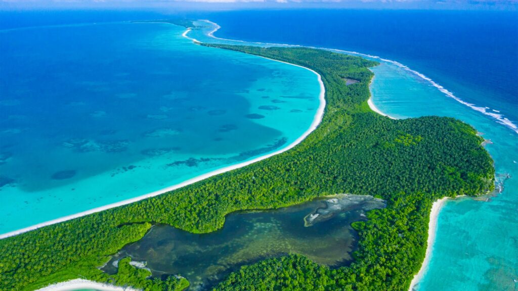
North Sentinel Island
One of the Andaman Islands in the Bay of Bengal, which are administered by the Indian authorities. This archipelago consists of almost six hundred islands, of which less than forty are inhabited. This is an absolutely heavenly sunny place with jungle and bounty beaches, but only a couple of dozen islands are open to foreigners, and about the same number can be visited during the day without spending the night.

The Andaman and neighboring Nicobar Islands are famous for the fact that several indigenous peoples still live there. Most of them have ceased to be non-contact and have already begun to come into contact with our civilization, little by little taking from it everything good and bad: medical care, clothing, food, the destruction of the traditional way of life, alcohol, tobacco, diseases and even children conceived from strangers. To prevent this process, Indian authorities establish reservations in those areas where Aboriginal people live compactly and restrict movement through these territories.
North Sentinel Island stands apart here. Firstly, it is located slightly away from the main archipelago, and secondly, the local guys are so aggressive towards visitors that this ultimately saved them. In the 70s, they attacked documentarians filming a film on the island for National Geographic. In 2004, when Indian authorities surveyed the island from the air to assess the effects of the tsunami, the Sentinelese fired arrows at the helicopter. The first peaceful contact took place only in the ’90s after researchers for a long time brought coconuts and iron products to the islanders as gifts, which were not found on the island. Now, even the number of Sentinelese is not known exactly – the population of the island is estimated to range from 50 to 150 people.
They are considered direct descendants of people from Africa who have lived here for about 60 thousand years. To protect the Sentinelese from the destructive influence of civilization, Indian authorities prohibited approaching the island closer than five nautical miles. The Coast Guard enforces this law. However, violators are usually punished by the islanders themselves. In 2006, Sentinelese shot and killed two fishermen who swam to the island. The bodies of those killed were never recovered. And in 2018, an American made his way to them, who allegedly wanted to preach Christianity to the natives. He paid Indian fishermen to bring him to the island, and two days later, the fishermen saw natives burying a body on the beach that looked very much like an American.
Chagos Islands
It is difficult for both foreigners and local residents to enter the territory of these atolls. The Chagos Archipelago is located 700 kilometers south of the Maldives, approximately halfway between Tanzania and Indonesia. Like Ascension Island, the archipelago is a British Overseas Territory, and the official name of the islands is the British Indian Ocean Territory. This is de facto. And de jure, according to the UN decision, Chagos should belong to Mauritius.
The islands of Mauritius and the Chagos Archipelago were uninhabited, but they always passed from colonizer to colonizer in pairs. They were both first discovered by the Portuguese. Then, Mauritius was settled by the Dutch, who were replaced by the French, who also received Chagos as a bonus to Mauritius. Under the French in the 18th century, the first permanent residents appeared in Chagos. They were enslaved Africans and Indian-hired workers who came here to work on coconut plantations. At the beginning of the 19th century, Britain captured Mauritius and took over Chagos.
In the late 60s – early 70s of the last century, the British began to build a military base here jointly with the Americans, and all the inhabitants – about 2 thousand people – were deported to Mauritius. Now, the entire population of the archipelago is military and base personnel. Naturally, there is no regular transport or even cruise ships, and if you suddenly want to sunbathe on the snow-white Chagossian beaches, you will have to get permission to travel and then also get there by private boat from the Maldives.
Sahrawi Arab Democratic Republic
A piece of Africa, which is signed on our maps as “Western Sahara,” de facto belongs to three states: most of it was annexed by Morocco, a small cape in the south is controlled by Mauritania, and a narrow strip of land that stretches across the desert from Algeria to the ocean along the entire Mauritanian-Western Sahara border is the Sahrawi Arab Democratic Republic.
Getting into the Moroccan part of Western Sahara is not difficult: de jure, you do not leave Moroccan territory, the border is not marked in any way, and no one checks passports. Moroccan Western Sahara is not as popular as Morocco itself, but people even come here to surf. There is a lot of state propaganda and close attention of the police and intelligence services to foreigners – journalists are suspected of many of them. The Moroccans annexed this territory in 1975, and ideas of independence are still strong here. You can even enter the Mauritanian piece on foot from the nearest town of Nouadhibou – if an overly vigilant military patrol does not interfere.
But getting into the territory of the independent SADR is much more difficult. You can’t come here from the Moroccan side. In addition to the fact that the parties are still de jure at war, Morocco has built a so-called “wall” along the front line – a sand and stone embankment about three meters high, along which there are minefields, barbed wire, sensor systems, and military posts. The total length of the fortifications is more than 2.5 thousand km. They are called the largest minefield on the planet.
Theoretically, it would be possible to get here from Algeria, but getting an Algerian visa and even permission to move freely through the desert is another quest. The easiest option is to travel from Mauritania. You just have to find transport, preferably with a local driver, so you know where the road is and where the minefield is.
In addition, you will need to obtain permission from the authorities of the SADR itself, who may not understand your intentions as a tourist. Although there really is tourism there – organized charity tours, thanks to which you can not only get acquainted with the culture of the local residents but also help them with money.
You can get to the SADR by road from Mauritania to the Moroccan part of Western Sahara. Here, the SADR authorities own a piece of desert, which on Google maps is labeled with the poetic “No Man’s Land.” There are no roads or any other infrastructure. There is trash everywhere, from plastic bottles and old household appliances to car wrecks. At one time, there was even a hut there with the flag of this same SADR – probably empty. This was where any signs of state power ended. Some people consider crossing this strip a full-fledged visit to the country, but this, of course, is absolutely not sporting.
Somalia
A country in which there has been a war for almost thirty-five years, tied to all sorts of clan and religious contradictions. Today, Somalia is actually several separate states, but even in the territory controlled by the government, power is so weak that various barmalei regularly blow up and kidnap people.
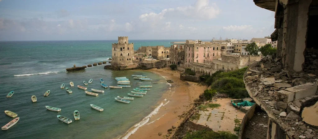
Flying to the Somali capital, Mogadishu, and getting a visa is quite simple. But for a foreigner, a simple walk around the city almost guarantees that you will be captured by some rabid bearded men. In fact, you are unlikely to even be allowed out of the airport without security. All foreign citizens live in a separate area of the city, which is guarded by soldiers and surrounded by concrete blocks in case of suicide car attacks. They go to the city exclusively accompanied by machine gunners.
Tourism also exists here: you can look at the destroyed colonial Italian architecture, and local life is very colorful. People come here on an organized tour, which includes armed guards and an overnight stay at a hotel in a protected area.
On the de jure territory of Somalia, there is an unrecognized state of Somaliland, which broke away during the civil war and declared independence in 1991 – although no country in the world has yet recognized it. At the same time, the Somalilanders turned out to be much more successful in building a state, and this territory is quite safe, except for the eastern outskirts. Therefore, many go there to boast about visiting “Somalia.”
Somalia is also a historical region inhabited by Somali clans. In addition to the state of Somalia, it includes the south of Djibouti, the east of Ethiopia, and the northeast of Kenya. The security situation there is different, but in general, it is much calmer than in Somalia. So these places can also be considered as an alternative.
Azawad
A historical region in northeastern Mali and the self-proclaimed republic of the same name. This region used to be a wildly popular tourist destination – relative to Africa, of course. There are a bunch of colorful clay settlements here. The number one local attraction is the UNESCO World Heritage site, the ancient city of Timbuktu, located on the banks of the Niger River. Yes, Timbuktu is not a bay, and the Secret group deceived us all.
However, in 2012, another uprising was launched by the Tuaregs living here, and then Islamists joined them – and things became restless. The tourist flow has dried up. Buses run regularly to these cities, but outside the cities, the territory is controlled by Tuaregs, Islamists, and Tuareg-Islamists. And since with white skin, it is impossible to get there without a fawn; there is a possibility of being taken hostage by the barmalei. Perhaps the only guaranteed safe option to get to Timbuktu is to fly there on a rented plane and move around the surrounding area with security.
Principality of Sealand
A virtual state with an area slightly smaller than a football field, located on a platform off the coast of Great Britain. During World War II, the British built a bunch of them to defend their coasts and sea routes from the Third Reich. Some of these platforms were built in international waters, which was illegal, but in those turbulent years, no one cared about such trifles.
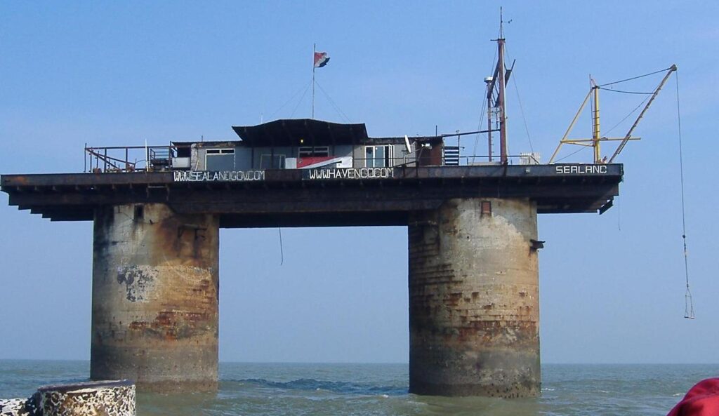
For some reason, one of these illegal platforms was not destroyed after the war, and in the 60s, it was squatted by British Army Major Roy Bates. Allegedly, in order to organize a pirate radio station here, British laws would not apply. The radio station never started working, but in 1967, Bates proclaimed the creation of the state of Sealand and later adopted its constitution, flag, anthem, and national currency.
During the war, 150–300 soldiers lived on the platform. In the early 70s, during the most “densely populated” times of the principality, there were about fifty. However, Sealand is never empty, and at least one person is always on duty here. The Sealanders fired warning shots at British ships in their territorial waters a couple of times and once even suppressed a coup d’etat when the prime minister of the principality, along with a detachment of mercenaries, broke through to the platform and took Bates’ son hostage. For the citizens of Sealand, this conflict had no consequences because the British courts decided that all events took place outside their jurisdiction.
Roy Bates died in 2012, but his son continues his work. Currently, there is no tourism in Sealand. For a long time, there was information on the official website that organized tours would begin soon, but then this page disappeared. For now, the state replenishes its coffers by selling Sealand ID cards, titles of nobility, and other souvenir trinkets.
Heard Island and McDonald Islands
These uninhabited volcanic islands in the southernmost Indian Ocean are perhaps the most inaccessible in the world. They are an Australian Outer Territory, a marine reserve, and a UNESCO World Heritage Site. To get there, you will have to obtain permission to land from the Australian authorities, but bureaucracy is not the most insurmountable obstacle.
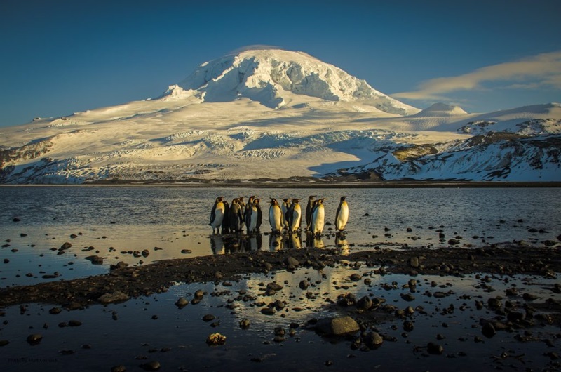
The most remote island in the world is the Norwegian Beauvais in the South Atlantic. The closest land to it is the uninhabited Antarctic coast, 1,600 kilometers away. Hurd and MacDonald will be closer to civilization: some 450 kilometers northwest of Hurd, and we come across the French Kerguelen archipelago, where several dozen scientists and military personnel live. But Beauvais is frequented by commercial cruise ships, and the only way to get to Hurd and Macdonald is to either join an expedition that happens every few years or organize a cruise yourself. It won’t be cheap, because from Australia you have to sail there for about two weeks through choppy waters, and then return for the same amount of time. But if you can, you can see active volcanoes, penguins, and the remains of seal-killing settlements from the 19th century.